Property Record
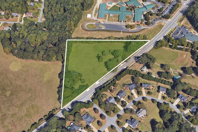
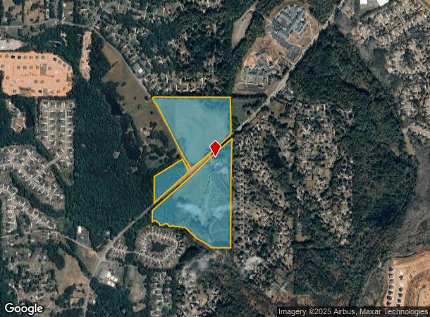
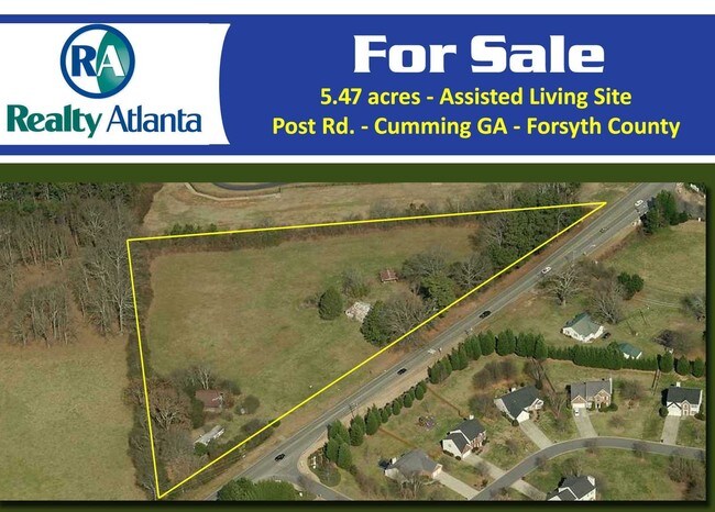
6489 Post Rd, Cumming, GA 30040

NEARBY LISTINGS FOR SALE OR LEASE
Property Detail
6489 Post Rd
Atlanta-Sandy Springs-Roswell, GA
Midway
037-007
2-1 318-331
Agriculturalland
Forsyth
A
Georgia
13117C0136F
318
2024
71.28 AC
2025
N Fulton/Forsyth County
130304
Atlanta
2,296 SF
DEMOGRAPHICS near 6489 Post Rd
1 Mile
3 Mile
5 Mile
2024 Total Population
5,045
44,362
119,017
2029 Population
5,867
51,008
136,565
Pop Growth 2024-2029
+ 16.29%
+ 14.98%
+ 14.74%
Average Age
38
38
38
2024 Total Households
1,658
14,424
39,724
HH Growth 2024-2029
+ 16.34%
+ 15.07%
+ 14.88%
Median Household Inc
$151,746
$142,008
$131,316
Avg Household Size
3.00
3.00
2.90
2024 Avg HH Vehicles
2.00
2.00
2.00
Median Home Value
$467,193
$480,036
$465,980
Median Year Built
2008
2005
2005
Nearby Places
Map Layers
Map Styles
 Street
 Aerial
- Restaurants
- Banks
- Shops
- Fitness
- Groceries
SALE & LEASE HISTORY
LISTING DATE
SALE/LEASE

Sep 24, 2016
For Sale
Nearby Properties
Address
Land Use
TOTAL SIZE
Lot Size
Zoning
Address
Land Use
TOTAL SIZE
Lot Size
Zoning
281,780 SF
19.08 AC
PUD
Address
Land Use
TOTAL SIZE
Lot Size
Zoning
10,908 SF
107.57 AC
RES3
Address
Land Use
TOTAL SIZE
Lot Size
Zoning
4,616 SF
12.30 AC
R3
Address
Land Use
TOTAL SIZE
Lot Size
Zoning
83,161 SF
277.43 AC
A1
Address
Land Use
TOTAL SIZE
Lot Size
Zoning
234,450 SF
95 AC
A1
Address
Land Use
TOTAL SIZE
Lot Size
Zoning
207,663 SF
60.62 AC
R2R
Address
Land Use
TOTAL SIZE
Lot Size
Zoning
42.50 AC
RES3
Address
Land Use
TOTAL SIZE
Lot Size
Zoning
16.56 AC
MP
Address
Land Use
TOTAL SIZE
Lot Size
Zoning
11,737 SF
34.75 AC
A1
Address
Land Use
TOTAL SIZE
Lot Size
Zoning
96,999 SF
10.93 AC
CBD
Address
Land Use
TOTAL SIZE
Lot Size
Zoning
80,598 SF
10.07 AC
CBD
Address
Land Use
TOTAL SIZE
Lot Size
Zoning
155,701 SF
10.35 AC
R3
Address
Land Use
TOTAL SIZE
Lot Size
Zoning
76,622 SF
49.06 AC
A1
Address
Land Use
TOTAL SIZE
Lot Size
Zoning
6.97 AC
M1
Address
Land Use
TOTAL SIZE
Lot Size
Zoning
121,176 SF
5.86 AC
M1
Address
Land Use
TOTAL SIZE
Lot Size
Zoning
138,941 SF
26.40 AC
RES3
Address
Land Use
TOTAL SIZE
Lot Size
Zoning
151,980 SF
8.77 AC
M1
Address
Land Use
TOTAL SIZE
Lot Size
Zoning
65,612 SF
6.83 AC
CBD
Address
Land Use
TOTAL SIZE
Lot Size
Zoning
6,298 SF
87.14 AC
A1
Address
Land Use
TOTAL SIZE
Lot Size
Zoning
25.76 AC
MP
Address
Land Use
TOTAL SIZE
Lot Size
Zoning
4,800 SF
28.71 AC
M1
Address
Land Use
TOTAL SIZE
Lot Size
Zoning
217,056 SF
24.55 AC
CBD
Address
Land Use
TOTAL SIZE
Lot Size
Zoning
52,173 SF
2.99 AC
CBD
Address
Land Use
TOTAL SIZE
Lot Size
Zoning
116,648 SF
16.50 AC
M1
Address
Land Use
TOTAL SIZE
Lot Size
Zoning
101,808 SF
2 AC
CBD
Address
Land Use
TOTAL SIZE
Lot Size
Zoning
123,630 SF
20.51 AC
CBD
Address
Land Use
TOTAL SIZE
Lot Size
Zoning
84,461 SF
19.52 AC
AG1
Address
Land Use
TOTAL SIZE
Lot Size
Zoning
69,380 SF
5 AC
M1
Address
Land Use
TOTAL SIZE
Lot Size
Zoning
76,080 SF
7.12 AC
M1
Address
Land Use
TOTAL SIZE
Lot Size
Zoning
450 SF
97.50 AC
M1
The World's #1 Commercial Real Estate Marketplace
Connect with us
© 2025 CoStar Group
The information above has been obtained from sources believed reliable. While we do not doubt its accuracy we have not verified it and make no guarantee, warranty or representation about it. It is your responsibility to independently confirm its accuracy and completeness. Any projections, opinions, assumptions, or estimates used are for example only and do not represent the current or future performance of the property. The value of this transaction to you depends on tax and other factors which should be evaluated by your tax, financial, and legal advisors. You and your advisors should conduct a careful, independent investigation of the property to determine to your satisfaction the suitability of the property for your needs.